|
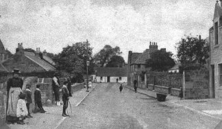
The High Street
c.1890. |
|
Corstorp hine today is a prosperous suburb of Edinburgh
about three miles to the west of the city centre, astride the main
Edinburgh-Glasgow road, but about a million years ago the ice that covered
Scotland melted and made lochs. Looking towards Corstorphine from where
Edinburgh Castle is now would have seen Corstorphine Loch stretching from
the Water of Leith at Roseburn to the street we call Station Road (a
railway station was there from 1902 to 1967).
There was another loch further west - Gogar Loch which
covered part of the land where the Dual-carriageway is from the Gyle
Shopping Centre to Edinburgh Airport. Between these two lochs was hard,
dry ground and there in time, the time we call B.C. men built simple huts.
That is how Corstorphine became a place where people chose to live and
where now, thousands of years later, people still choose to live.
|
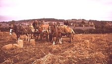
Farming on Broomhouse
Farm c.1950.
|
Corstorphine was a village where people grew food crops
and kept cattle. It was not part of the town of Edinburgh. In fact it did
not become part of Edinburgh till 1920. Even in 1920 - not very long ago -
Corstorphine was still a farming place supplying Edinburgh with milk,
butter, eggs, potatoes, and rhubarb.
|
|
| But by 1939
Corstorphine had begun to change from a village to being part of a city.
The old village was where the church is at the foot of Kirk Loan near the
Library and along the High Street past the school to Ladywell Health
Centre. |
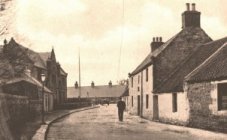
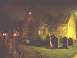
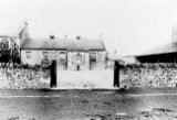
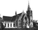
Irish Corner,
The High Street
c.1890. |
|
|
Growing Corstorphine
About a
hundred years ago some people who wanted to live in Corstorphine chose to
build homes up the hillside on Clermiston Road. From there they had a fine
view across the old village to the Pentland Hills.
Craigmount High
School 1999. |
Next, between 1920 and 1939,
more houses, named Hillview (Terrace, Crescent, Drive, and Road) were
built. Other houses were built between the old village and the Broomhouse
Farm and Carrick Knowe Farm. Then after 1945 more houses appeared on the
hill slopes called the Craigs and on the fields of North Gyle Farm. A new
school - Craigmount - was also built. So now the farm fields have almost
all gone to make space for houses and supermarkets.
|
Corstorphine goes on getting
bigger and bigger. You may know new Corstorphine but how much do you know
about old Corstorphine? Let's look at some of the things from the old
village.
|
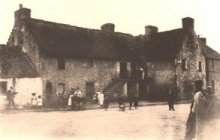
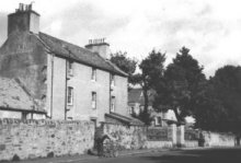
The Foot
of Kirk Loan c.1910. |
Possibly
the oldest part of Corstorphine is the foot of Kirk Loan. You may have
noticed how the
road opposite the Library where the church stands is shaped like a curve.
The church and the curved ground are both signs of Christianity being
there before the year 1000. We do know there was a chapel by the year
1128. |
|
|
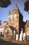
The present church was begun
in 1429 so it has been there a long time watching Corstorphine folk
passing by.
The family
who arranged for masons to build the church were the Forresters. They
lived in a castle built about 1390 in the part of Corstorphine we now
called Castle Avenue. |
|
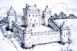
What the Castle may have
looked like in its Heyday!.
|
When the Forresters left Corstorphine around 1700
the next owners, the Dick family did not live long in the castle because
at the other side of Edinburgh, near Duddingston Loch, they had another
house which today is Prestonfield Hotel.
The Dicks let the castle
become a ruin and by 1870 only a few stones remained in the field.
|
|
One
building, however, from the castle grounds still survives: it is the
dovecot kept by the Forresters to give them fresh pigeon meat in the
winter. Inside the dovecot are 1060 nesting boxes or pigeonholes. That, by
the way, is how we get the word "pigeon-hole" meaning a small
compartment in a writing desk in which papers are kept. |
|
|
The
road to the castle, an avenue of trees, passed close to the dovecot. Until
recently one lovely tree remained - the sycamore at the corner of Dovecot
Road and Saughton Road. This tree has the more unusual distinction because it does not produce
seeds and can only be propagated from cuttings. It is also a botanical
subspecies on its own giving its name to the species - Acer
pseudoplatanus corstorphinensis. Its nearest daughter tree is at the
gate way to the Old Parish Church, at the east end of the High Street. |
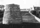
The Old
Dovecot.
|
|
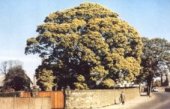
The Corstorphine Sycamore
Tree in 1960. |
Unfortunately the winter storms of 1998 brought
this tree down and only a stump remains. There is an exciting story about
the sycamore tree. James, Lord Forrester, in August 1679 was murdered
there by his niece, Christian Nimmo. Later she was put to death in
Edinburgh for killing her uncle. Her ghost, in a white dress, is said to
haunt the tree. I haven't seen her but some years ago a Corstorphine
gardener said he had seen the "White Lady". |
|
|
Look, too,
at the church wall above the big window in Kirk Loan. You will see, high up, a
small hollow (called a niche) with a lamp standing in it. This is a modern
electric light which Corstorphine Rotary Club gifted to the church in
1958. When lit on winter evenings the light reminds people of the oil lamp
that was kept there long ago by the priests to guide travelers across the
boggy ground between Edinburgh and Corstorphine.
|
|
To pay for lamp oil the
church was given the rent from an acre of ground beside the Water of Leith
at Murrayfield, roughly between the Kwik Fit premises and the bridge over
the river at Riversdale. When the lamp was not used in the 17th century
the rent of the Lamp Acre was given to the schoolmaster as part of his
wage. |
The Restored Lamp lit at night. |
|
|
The area in
front of the church is now open grass and the War Memorial. Up till 1928
there were cottages there known as Irish Corner because Irish people lived
there. Some came in 1818 to help to build the Union Canal. Others came in
1842 to work on the Glasgow and Edinburgh railway. Others worked on farms,
especially when potatoes had to be lifted.
At the east
end of St. Margaret's Park you see a large white house traditionally
called Gibsone’s Lodge or The Dower House. Some people think this is
where the old Lady Forrester would live when her husband died and her son
took over the castle. What we do know is that in the early 17th century it
belonged to a man who owned it as part of the church property so it may
have been the house of one of the priest's helping the Provost. Some
people remember it as Gibson Lodge because the lady who lived in there
about 1800 was Henrietta Watson of Saughton, wife of Sir John Gibsone of
Pentland.
|
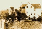
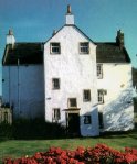
The Dower House. |
It has now recently be renamed The Corstorphine
Heritage Centre and is the Headquarters of The Corstorphine
Trust. The
Corstorphine Trust is a local community association dedicated to the stimulation of public interest in the character
and history of Corstorphine. They encourage the preservation, development
and improvement of
features of general public amenity or historic interest.
|
|
|
Opposite
St. Margaret's Park is the village school. Before 1819 the school was a
thatched cottage in the High Street near the path leading to the United
Free Church. In 1819 a little new school was built with a house for the
teacher. A bigger school was built in 1848, and then in 1894, and in 1932
further additions were made.
|
The Primary School c.1890.
|
|
The Mansion House,
The High Street
c.1950. |
In 1952 the
large house called the Mansion House next to the school was removed to
give the school more space. The Mansion House built about 1750 was a kind
of hotel for sick visitors who came to drink the waters of the Physic
(medicinal) Well in the hope their illness would be cured. |
|
|
If you go to
Dunsmuir and walk to the bottom. There you will see the stone edging that
once bordered the Physic Well. This well was hidden beneath the ground and
in 1972/73 when the Stank burn was enclosed in pipes this well head was
resorted. The stank a ditch dug in the 17th century to drain the marshy
ground. It started a little beyond the Royal Scot Hotel and ran to join
the Water of Leith at Riversdale near Murrayfield Ice Rink. The name Stank
comes from a French word meaning a pond or pool. |
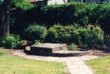
The Restored Physic Well Head. |
|
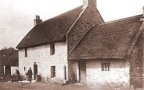
Claycott Dairy c.1890. |
At the end
if the High Street where it meets Ladywell Avenue is a group of new houses
called Claycot but the name of the old farm which stood there was Claycott.
The name probably reflects the nature of the soil - heavy clay. For nearly
the whole of the 18th century Claycott was worked by the Gloag family. The
farmhouse which has been altered in height and with windows added this century
survives as part of the Claycot complex. Traditionally Prince Charlie's
troops are said to have rested here just before his entry to Edinburgh in
1745. The Prince is said to have been at the Dower House.
|

The Claycott
housing complex
today. |
|
|
St. Ninian's Church, St. John's
Road. |
Facing you
at the top of Manse Road is St. Ninian's Church. In 1843 some people left
the old church at Kirk Loan and set up their own church. They did this
because they wanted to be free to choose their minister for at that time
the minister was chosen by the landowner not by the ordinary people.
Leaving the old church was called the Disruption. The new church was
called the Free Church. In 1929 many of the Free Churches joined again the
old Church of Scotland and when this happened in Corstorphine the Free
Church was re-named St. Ninian's. St. Ninian was an early missionary to
Scotland. |
|
|
In 1872
horse drawn buses came from Edinburgh to the village. Inns like the Harp
and the Oak were set up to give the weary travellers food and beds.
|
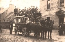
The Horse Coach at the Oak
Inn, St.John's Road c.1890.
|
|
|
So St.
John's Road became a highway between Edinburgh and the west of Scotland.
In the 1930's the giant rudder for a great ocean going ship was
transported along St. John's Road from Tyneside to the Clyde.
OH! I
NEARLY FORGOT... HOW DID CORSTORPHINE GET ITS NAME?
Place-name
enthusiasts argue endlessly about the origins of the name
"Corstorphine". Many now consider it has come from come from the
GAELIC language meaning a White Hollow in a Wet Place (CORIE STOIR FIONN).
Preserve
our Heritage
Our past is
looked after by The Corstorphine Trust, a local heritage body set up just
after the World War II to ensure that Corstorphine's history and identity
would not be lost. Its Headquarters, a fine 17th century house, The
Corstorphine Heritage Centre (Dower House) is in St. Margaret’s Park
(off the High Street).
|